
Building sovereign Earth observation capabilities for Australia
Ground stations and data pipelines can start now, on satellites already in orbit, and build toward a constellation that can look at any part of Australia and its surrounds, at any time.
Australia can build sovereign Earth observation capability in steps. Ground stations and data pipelines can start now, on satellites already in orbit, and they are what a constellation will need later. This page proposes that constellation. Its designs are provisional, and every figure on this page is modelled.
A constellation built here makes the strongest case for building Australian space capability: the satellites, their optics, the ground stations, and the people who run them. That capability helps Australia and its close allies, such as the United States.
Start now: ground stations and data pipelines#
Earth observation data for time-sensitive missions is only as good as the downlink and the processing behind it. A satellite that sees a fire helps no one until its data reaches the people who act on it.
We do not need to wait for new satellites to start. A data pipeline on the satellites already in orbit turns their data into actionable information for Australian stakeholders now, and ground stations bring that data down sooner. Both get the most out of every later Australian mission, this constellation included.
Fire, our first pipeline, starts with Himawari's fire band. We build and operate data pipelines on sovereign compute.
The proposed constellation#
The goal is to be able to task a satellite to look at any area in Australia and its surrounds, at any time. That needs a large enough constellation. From high low Earth orbit (LEO) or medium Earth orbit (MEO), each satellite sees far more of the ground, so fewer satellites are needed.
Spotting fires is where this matters most. A fire can start anywhere, day or night, in remote country, and the first minutes after ignition matter most. When Himawari flags a possible fire in one of its 2 km pixels, a pipeline could task a satellite overhead to look closer, and confirm the fire or rule it out.
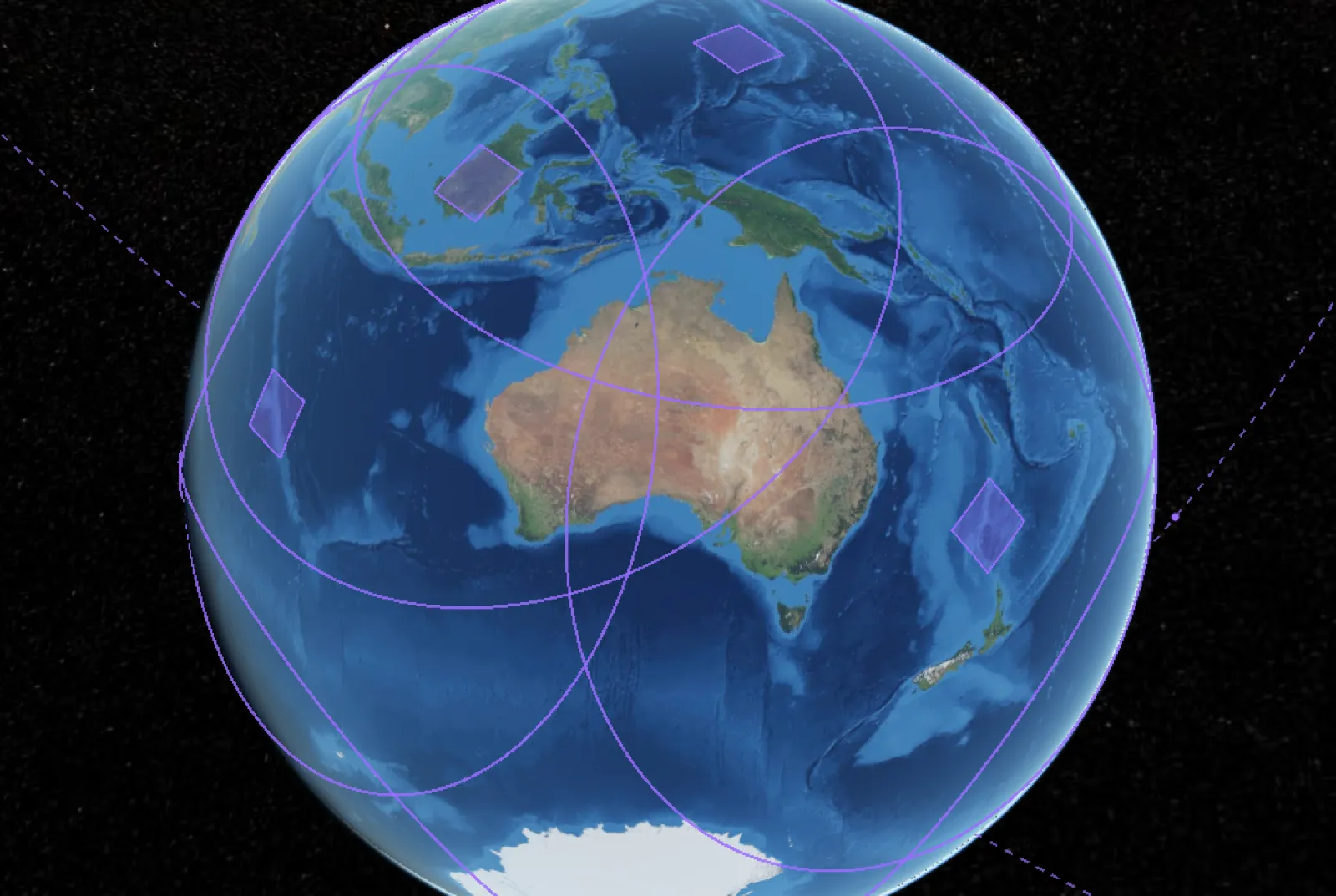
Modelled: 12 satellites in medium Earth orbit, 10,000 km up, in two planes at 35°. Each ring is the ground one satellite's imager can be pointed at, within 60° of overhead. Each square is one frame of an imager looking straight down. The satellites are placed at an arbitrary moment: the pattern, not a schedule. Modelling by Janis Lesinskis. Drawn with CesiumJS. Earth: NASA Blue Marble, from NASA's Global Imagery Browse Services (GIBS).
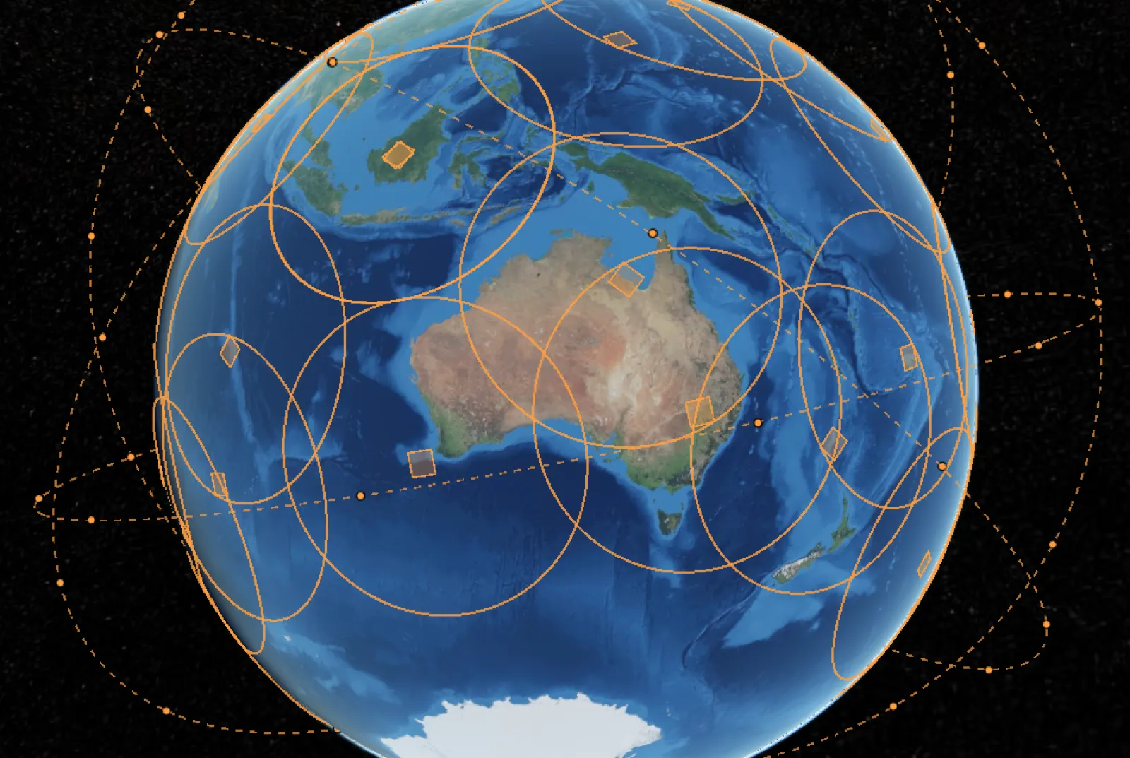
Modelled: 48 satellites in high low Earth orbit, 1,800 km up, in four planes at 35°, on the same scale. Rings and squares as above: more satellites, each seeing less of the ground. Modelling by Janis Lesinskis. Drawn with CesiumJS. Earth: NASA Blue Marble, from NASA's Global Imagery Browse Services (GIBS).
Pointing and tasking are what make "any time" possible. Each satellite's imager is steered to the place asked for, anywhere within its field of regard, rather than seeing only the frame below it. The table compares the same satellites with imagers that can be pointed and with imagers fixed looking straight down.
| Design | Imagers that can be pointed: longest wait | Imagers fixed looking straight down |
|---|---|---|
| 12 satellites in MEO, 10,000 km up | 3 minutes | 2 of 94 places not seen in 3 days; the rest wait up to about 47 hours |
| 48 satellites in high LEO, 1,800 km up | 5 minutes | 5 of 94 places not seen in 3 days; the rest wait up to about 6 hours |
| 24 satellites in high LEO, 1,800 km up | 15 minutes | 5 of 94 places not seen in 3 days; the rest wait up to about 9 hours |
| 48 satellites in LEO, 600 km up, for comparison | 27 minutes | 2 of 94 places not seen in 3 days; the rest wait up to about 7 hours |
Modelled, not measured. Each figure is the longest any of 94 places waits for a satellite over three simulated days. The places are 300 km apart across the mainland, Tasmania, and islands within 100 km of either. An imager that can be pointed sees a place whenever its satellite is within 60° of that place's overhead, one request at a time, with no time allowed to turn. A fixed imager sees only a swath one frame wide below it. The frames come from placeholder fields of view, about 700 km across in MEO and 295 km at 1,800 km, and a wider frame would narrow the gap. A satellite looking at a place is not the same as finding a fire there: that also depends on the fire's size and heat, the imager, cloud, and smoke.
Processing on board completes the system. A satellite that processes its own images can rebroadcast what matters efficiently, and tasking becomes much clearer.
Why not only geostationary#
Geostationary orbit was once the only way to watch a place continuously. It no longer is: a large enough constellation in lower orbits can be tasked to any place at any time, from much closer.
Geography matters too. A geostationary satellite sits above the equator, so it sees the cities and coastal fringe where most Australians live at a slant. Only the north is seen close to overhead. The detector is unchanged; each pixel simply lands on a larger patch of ground. Over Sydney and Adelaide, a geostationary pixel covers about 40% more ground than it does beneath the satellite. Over Melbourne and Perth it covers 50 to 60% more, and over Hobart about 75% more, with the light passing through more atmosphere on the way. Small fires, the ones worth catching early, become harder to pick out from the background. Satellites in lower orbits look from much closer, and at steeper angles, across the whole continent.
A geostationary mission also concentrates the capability in a few expensive spacecraft. Lose one and the coverage goes with it. A constellation spreads the same job across many satellites. Lose a satellite and the constellation keeps operating, with slightly longer waits, while a replacement carrying newer sensors goes up on a small launcher. For a sovereign capability, that resilience carries as much weight as resolution.
Geostationary satellites still have a role. With no motion relative to the ground, they give the highest temporal resolution, and they can help task the other platforms. Satellites in low orbits add to the system too: they can calibrate and validate the data, and take opportunistic tasks as they pass.
The case for sovereign capability#
A committed constellation is a demand signal from government. The facilities that build satellites, optics and ground systems need stable future demand to operate and to build their staff, and a constellation gives them that.
The constellation's large optics give a space optics fabrication industry in Australia the chance to build up. The satellite bus ecosystem it creates enables space astronomy, and future Earth observation missions. Downlink and ground stations help the entire Australian space sector, and open opportunities for collaboration with other countries' space agencies.
Capability built here serves Australia and its close allies.
What can be built in Australia#
Much of the build can be done here, and some of it already is:
- Satellite buses. A mix of larger buses, 200 to 400 kg, for high LEO and MEO, and CubeSat buses for lower LEO. Satellite buses are already built in Adelaide, Sydney, and Canberra.
- Optics. Space optics can already be made in Australia.
- Ground stations and downlink. Providers already operate here.
- Data pipelines, on the ground and on board.
- Space operations. Companies already run satellite operations, and the capability can be built up in government departments.
Contact#
If you want us to work on part of this, or on something else, tell us. Start a conversation