
Fire: sub-pixel fire location from existing Himawari data
Fire turns satellites already watching Australia into fire locations an agency can act on. It needs no new hardware and no launch.
Fire is built in stages. Each stage gives fire operators a better product in its own right. Together, the stages measure how far existing satellites can be pushed, and what only a sovereign Australian satellite can add.
Background#
Australia's national hotspot product, DEA Hotspots, places Himawari detections to within ±2 km and publishes them about 20 minutes after observation. Geoscience Australia states the product is not accurate enough for time-critical fire detection and location.
The same error shows up overseas. A March 2026 study in Remote Sensing found about 12% of fire detections from the US GOES satellites misaligned with matching VIIRS detections, with offsets of several kilometres.
Requirement#
Within minutes of ignition, a fire agency needs to know where the fire is, how hot it is, and where it is heading. Location comes first. Every other decision depends on it.
Why pixel size matters#
A geostationary weather satellite sees Australia in pixels about 2 km across. A new fire fills a small fraction of one pixel, so its position inside that pixel is unknown, and the satellite's viewing angle over terrain shifts it further.
The 2018 Camp Fire shows the effect. Simulated at four pixel sizes, the same fire covers:
- 8,417 pixels at 45 m
- 2,110 pixels at 90 m
- 144 pixels at 375 m
- 6 pixels at 2.2 km
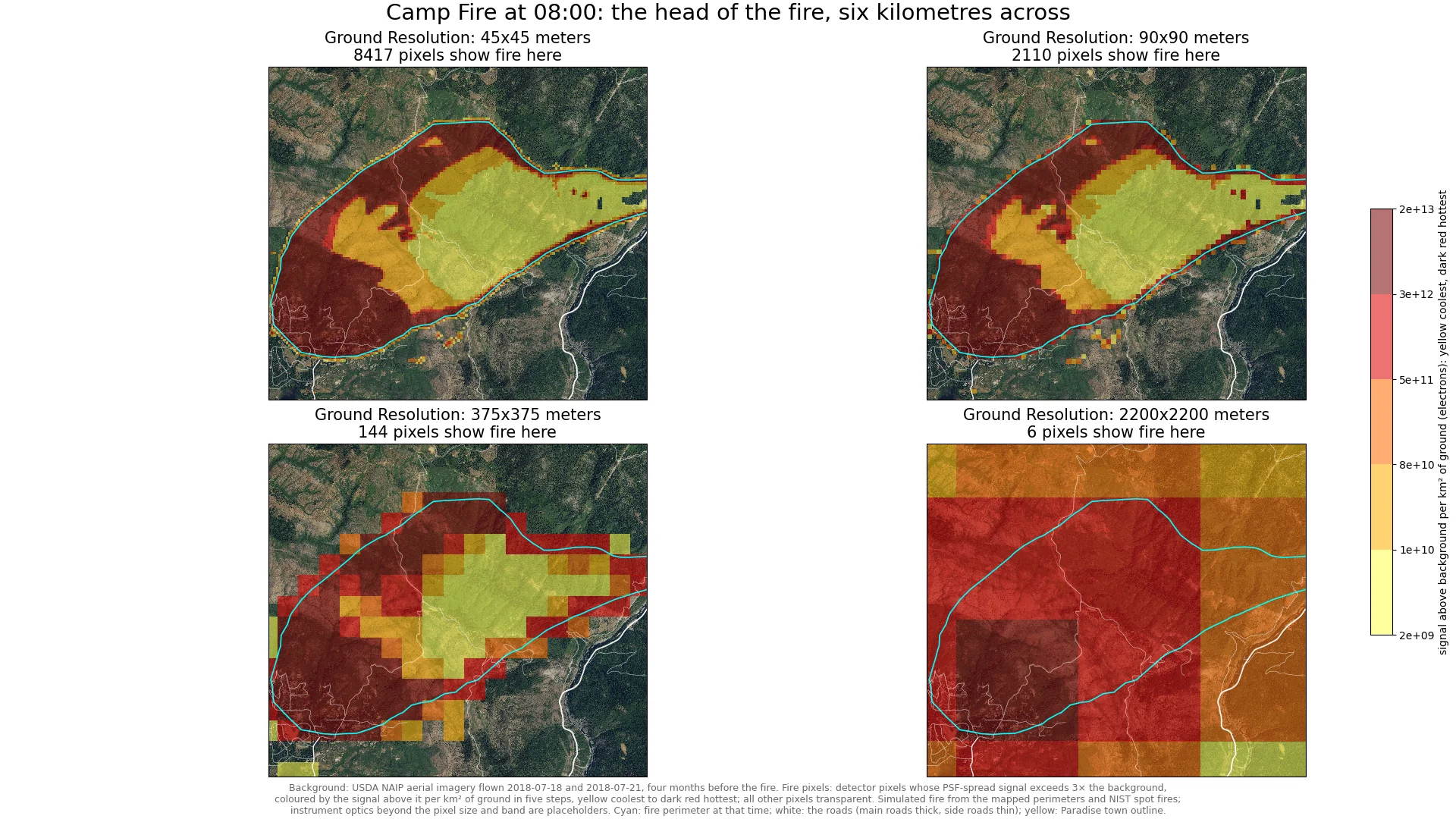
Simulated: the head of the 2018 Camp Fire in California at 08:00, six kilometres across. At 2.2 km, the scale of a geostationary fire band, six pixels show fire. Simulation by Janis Lesinskis. Background imagery: USDA NAIP.
At 09:00, the GOES-16 satellite saw the fire in about 20 pixels.
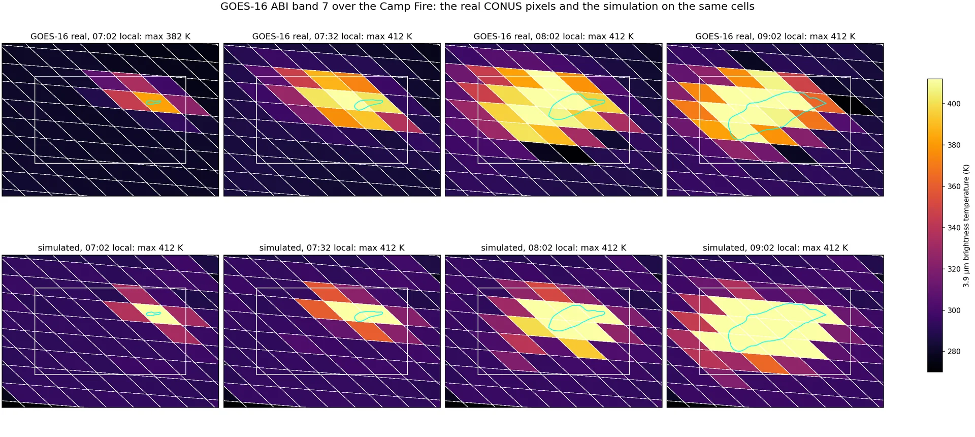
GOES-16 Band 7 at 3.9 µm over the Camp Fire: real pixels above, the simulation of the same cells below, and the mapped perimeter outlined. At 09:00, about 20 GOES-16 pixels show the fire. Locating it inside them is the problem Fire works on. Real data: NOAA GOES-16. Simulation: Janis Lesinskis.
Our approach#
Himawari-8 and 9, operated by the Japan Meteorological Agency, carry the Advanced Himawari Imager. It uses the same fire channels as the GOES imager: Band 7 at 3.9 µm, where a small fire shows first, and Band 14 at 11.2 µm. Both are 2 km channels.
Fire processes that data on the ground. It corrects each detection for terrain, and for the way the sensor spreads a point of heat across neighbouring pixels, using Himawari's own scan geometry. Over high terrain, uncorrected parallax can misplace a fire on GOES by 5 km or more.
The result is fire location at improved resolution from data agencies already receive. The satellite, its ground segment, and its data distribution stay as they are.
Staged program#
Each stage delivers a working product and produces the evidence for the next.
Stage 1a: corrected fire location from Band 7 (available now)#
A data pipeline that corrects Himawari Band 7 fire detections for terrain and sensor blur. Found To Fixed owns and operates the pipeline on sovereign compute and licenses the output to the customer. Agencies get better fire locations in their first season, from a satellite they already rely on.
Stage 1b: multispectral processing (next)#
Up to three more bands, starting with Bands 14 and 11. Location and temperature accuracy improve, and false alarms fall.
Stages 2 to 4: a sovereign fire satellite (future)#
Stage 1 measures how far software can take existing satellites. What software cannot correct, 2 km pixels and reliance on a satellite Australia does not operate, defines the requirement for an Australian mission.
- Stage 2: preliminary design of a satellite mission for better revisit and geolocation
- Stage 3: critical design and planning, including component sourcing, funding, and partners
- Stage 4: build, launch, and operation of a fire data service from orbit
Design gates sit between mission stages: preliminary design, critical design, and design locked. Funders see measured Stage 1 results before any hardware decision.
One shape that mission could take is set out in our proposal for building sovereign Earth observation capabilities for Australia: a constellation that can look at any part of Australia at any time.
Validation#
Fire is tested on the Himawari-8 archive for the 2019-20 Australian fire season, against VIIRS at 375 m and Landsat at 30 m. Results report geolocation error in metres, detection rate, false alarm rate, a combined accuracy score (F1), and the time from observation to output.
Data sovereignty#
Jurisdiction requirements for acquisition, transmission, storage, processing, and insights are set before any data moves. Each customer decides whether one instance serves all jurisdictions or each jurisdiction holds its own.
Operation#
Found To Fixed runs the pipeline, including compute, monitoring, and the time from observation to output. Availability targets come from what agencies need during an event.
Safety position#
Public warnings come only from the responsible fire agency. Fire outputs reach the public through that agency, carry a stated confidence, and never contradict an official warning.
Scope exclusions#
- Building AI or machine learning models (Fire supplies labelled data for them)
- Issuing public warnings
- Fire spread prediction in Stage 1a
- Any change to the satellite, its ground segment, or data distribution
Team#
Janis Lesinskis leads the science. He spent four years on fire detection at Fireball, then worked on UC Berkeley's FUEGO wildfire detection project at the Space Sciences Laboratory. The Fire method builds on his GOES work.
Contact#
Tell us where fire data falls short today. Start a conversation